Wednesday, October 31, 2012

October 31, 2012 - Sydney (YRE)


Sydney is located on Cape Breton Island in Nova Scotia.  The 2011 population of the Sydney census area was 31,597, making it the largest population center on Cape Breton Island.

Sydney was founded in 1785 by Colonel Joseph Frederick Wallet DesBarres, and was named in honor of Thomas Townshend, 1st Viscount Sydney who was serving as the Home Secretary in the British cabinet.  Sydney, Australia was also named after him in 1788.

The indigenous Mi'kmaq were joined by Scottish, English, Irish and French (Acadian) settlers. Later, Loyalists from the state of New York, fleeing the aftermath of the American Revolution, were added to the mix.

By the early twentieth century Sydney became home to one of the world's largest steel plants, fed by the numerous coal mines in the area.  

Sydney Harbour played an important role during World War II after a Royal Canadian Navy base, HMCS Protector, was established to stage supply convoys bound for Europe. They tended to be slower convoys and had the prefix SC (for Slow Convoy). Convoy SC-7 typified the dangers inherent with the Nazi U-boats off the coast of Cape Breton and Newfoundland during the Battle of the Atlantic. Sydney's coal shipping and steel manufacturing were essential ingredients in the Allied victory, however federal Minister of Industry, C.D. Howe favored Central Canada's steel industry given its proximity to a larger workforce and less exposure to coastal attack. The lack of significant war-time investment in Sydney's steel plant led to its decline after the war from which it was unable to recover.

By the late 1960s the coal and steel industries had fallen on hard times and were taken over by the federal and provincial governments and both industries were permanently closed by the end of 2001. Forced to diversify its economy, Sydney has examined a variety of economic development possibilities including tourism and culture, light manufacturing and information technology.

The local Volkssport Club accommodates cruise passengers by participating in the CVF Dock and Walk Program.  This allows one to begin the walk right at the cruise dock.

Our walk started at the "big fiddle" on the cruise ship dock."  This is a "ceilidh" fiddle and represents the Scottish Gaelic culture of this area.  A ceilidh is an informal "kitchen party" featuring lively music and dancing.

St. Patrick's Catholic Church (built 1828-1830)

Jost Heritage House Museum (c. 1787)
Cossitt House Museum (1787)
We walked past the Civic Centre and City Hall to the Cambridge Suites, where the start box was located.  Other points of interest on our 5k walk included several small museums and historic churches.


dining room
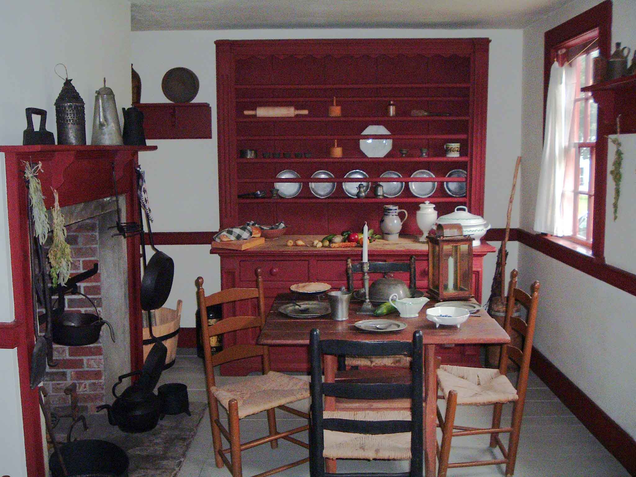
Inside Cossitt House

Bank of Montreal
St. George's Anglican Church (built 1785-1791)

Walk Route: C

Walk Instructions: C+

Thursday, October 25, 2012

October 25, 2012 - Québec Haute-Ville (Upper Town) (YRE)

Founded in 1608 by Samuel de Champlain, Quebec City is one of the oldest cities in North America. The ramparts surrounding Old Quebec are the only remaining fortified city walls that still exist in the Americas north of Mexico, and were declared a World Heritage Site by UNESCO. Quebec City is the capital of the province of Quebec. As of 2011, the city has a population of 516,622, and the metropolitan area has a  population of 765,706.

Guided snowshoe tours are offered in the winter


Our 10k walk began at Collège Merici at the far end of the Battlefields Park, which includes the Plains of Abraham.  Established as a park in 1908, it features an interpretive center and walking/snowshoeing/skiing trails, and is sometimes used for outdoor concerts. 


The Battle of the Plains of Abraham, also known as the Battle of Quebec, was a pivotal battle in the Seven Years' War (referred to as the French and Indian War in the United States). The battle, which occured on 13 September 1759, was fought between the British Army and Navy, and the French Army, on a plateau just outside the walls of Quebec City, on land that was originally owned by a farmer named Abraham Martin, hence the name of the battle. The battle involved fewer than 10,000 troops between both sides, but proved to be a deciding moment in the conflict between France and Britain over the fate of New France, influencing the later creation of Canada.

The culmination of a three-month siege by the British, the battle lasted about 15 minutes! British troops commanded by General James Wolfe successfully resisted the column advance of French troops and Canadian military under Louis-Joseph, Marquis de Montcalm, using new tactics that proved extremely effective against standard military formations used in most large European conflicts. Both generals were mortally wounded during the battle; Wolfe received a blow that would end his life within only a few minutes of engagement and Montcalm died the next morning after receiving a musket ball wound just below his ribs. In the wake of the battle, France's remaining military force in Canada and the rest of North America came under increasing pressure from British forces.
While the French forces continued to fight and prevailed in several battles after Quebec was captured, the British did not relinquish their hold on the fortress. That tenacity carried over to other areas in North America; within four years, with the Treaty of Paris, most of France's possessions in eastern North America would be ceded to Great Britain.


One of the Martello Towers
 The park contains a collection of about 50 historical artillery pieces scattered about its grounds and three surviving Martello Towers. Built by the British to prevent the Americans from drawing close enough to lay siege to the walls of Quebec, four Martello towers were begun in 1808 and completed in 1812. The towers were arranged to provide for each other's defense, and to screen the western approach to Quebec City. The limited openings on the towers were designed to prevent the enemy from taking it by storm, while the tower's rounded shape (to deflect projectiles) and thick masonry walls made them nearly impervious to artillery fire.


The doors to the towers are at a height of two and a half times the height of a man and could only be reached by a removable ladder. The towers were never tested in battle, and became obsolete in the 1860s with the development of rifled artillery, which was powerful enough to breach their walls.
The doors to the towers were made small so that it would be difficult for witches and spiders to get in

The Martellos were originally fitted with removable roofs in the fall to keep snow from accumulating on the gun platform at the top and removed in the spring. The roofs were later replaced with newer permanent ones which look almost the same.

Our route continued past the Musée National des Beaux-Arts du Québec and past a section of the park that was nicely decorated for Halloween.  I couldn't help thinking that in most urban parks in the US, such decorations would be stolen or vandalized.


We continued our walk in the direction of the Citadel, part of the fortifications of Quebec City. The first protective wall was built in the 17th century by the French. Considerable work took place on the fortifications after the fall of Louisbourg in 1745. The existing star-shaped fortifications were built by the British between 1820 and 1831 and incorporated a section of the French enclosure of 1745. Their purpose was to secure the strategic heights of Cap Diamant against the Americans and to serve as a refuge for the British garrison in the event of attack or rebellion. The Quebec Conferences of 1943 and 1944, in which Winston Churchill, Franklin D. Roosevelt, and William Lyon Mackenzie King discussed strategy for World War II, were held at the Citadel.


View from the Promenade
A magnificent boardwalk, Promenade des Gouverneurs, links the Battlefields Park with the Château Frontenac . Anchored on a sheer cliff and offering expansive views over the Saint Lawrence River, the boardwalk extends nearly half a mile.

The Emerald Princess and a ferry could be seen from the Promenade
At the end of the Promenade, we arrived at the magnificent Château Frontenac. The hotel was designed by American architect Bruce Price, as one of a series of "château" style hotels built for the Canadian Pacific Railway during the late 19th and early 20th centuries.  CPR's policy was to promote luxury tourism by appealing to wealthy travelers. The Château Frontenac opened in 1893, six years after the Banff Springs Hotel, which was owned by the same company and is similar in style.


The Frontenac was named after Louis de Buade, Count of Frontenac, who was governor of the colony of New France from 1672 to 1682 and 1689 to 1698. The Château was built near the historic Citadel, the construction of which Frontenac had begun at the end of the 17th century. The Quebec Conference of 1943, mentioned above, was held at the Château Frontenac and at the nearby Citadel.

Although several of Quebec City's buildings are taller, the landmark hotel is perched atop a tall cape overlooking the Saint Lawrence River, affording a spectacular view. The building is the most prominent feature of the Quebec City skyline as seen from across the St. Lawrence.  Although the word "iconic" tends to be overused, it is the perfect word to describe this building.

Copper Top
In 2011, work began on replacement of the main tower's copper roof, at the cost of $7.5 million. An image of the roof was printed on polypropylene safety netting and hung from scaffolding to hide the refurbishing project from view.  The new roof has not yet oxidized, so it appears to be copper-colored, rather than the green you might be familiar with.


In 1953, this hotel was used as filming location for Alfred Hitchcock's film I Confess, featuring Montgomery Clift and Anne Baxter.  


From the Frontenac, our route proceeded through the Old City, where we saw many historic churches, shops and restaurantsWe passed within half a block of Aux Anciens Canadiens where, the night before, we had enjoyed a traditional French Canadian meal in the oldest house in Quebec (built 1675-76).


Quebec Parliament


Grande-Allée
Passing out and in and out of the walled city through three of its historic gates, we  arrived at the Quebec Parliament.  From this point, we walked down Grande-Allée past many more interesting old buildings, finally returning to the Collège Merici via Battlefields Park.

Walk Route: A+
Walk Instructions: C


Sunday, October 21, 2012

October 21, 2012 - US FreedomWalk Festival, Day 3

C & O Canal

After yesterday's 13k walk, we opted for the 6k walk on this final day of the FreedomWalk Festival.

Immediately after walking across Key Bridge, we descended to the towpath of the C & O Canal. The Chesapeake and Ohio Canal, occasionally referred to as the "Grand Old Ditch," operated from 1831 until 1924 parallel to the Potomac River from Cumberland, Maryland, to Washington, D.C. The total length of the canal is about 184.5 miles (296.9 km). The elevation change of 605 ft (184 m) was accommodated with 74 canal locks. To enable the canal to cross relatively small streams, over 150 culverts were built. The crossing of major streams required the construction of 11 aqueducts. The canal also extends through the 3,118 ft (950 m) Paw Paw Tunnel. The principal cargo was coal from the Allegheny Mountains. The canal way is now maintained as a park,  the Chesapeake and Ohio Canal National Historical Park, with a linear trail following the old towpath.
After passing a few locks, we arrived at the C&O Canal Visitors Center and the checkpoint. We continued along the towpath through Georgetown, passing old buildings and brand new ones on both sides of the canal.   


A lock and a canal barge

The canal towpath ended at Rock Creek Parkway and we walked up to Pennsylvania Avenue. After a few blocks we reached the campus of George Washington University and walked right past the George Washington University Hospital - where I was born!


Continuing through the Foggy Bottom neighborhood, we passed the Watergate complex and the Kennedy Center. Our route continued over the Roosevelt Bridge to a bike trail on the Arlington side of the Potomac.  


View towards Georgetown from the Roosevelt Bridge
Walk Route: B+

Walk Instructions: A

Saturday, October 20, 2012

October 20, 2012 - US FreedomWalk Festival, Day 2

Washington, DC

Today was Day 2 of the U.S. FreedomWalk Festival.  We selected the 13k walk. Some hardy souls selected 22k or 42 k ("the marathon").  

Georgetown University
Starting in Rosslyn, we walked across the Key Bridge to Georgetown.  We were treated to nice views of Georgetown University from the middle of the bridge.  


On the DC side of the bridge, we followed Canal Street until we came to the Glover-Archbold Trail.  (The 183-acre Glover Archbold Park was donated to the city in 1924 by Charles C. Glover and Anne Archbold - a former Riggs Bank executive and Standard Oil of New Jersey heiress, respectively - to be used as a bird sanctuary. It contains trees that are 150 to 200 years old.) We followed a pleasant path through Rock Creek Park for about 3k.  It was surprisingly "woodsy" for Washington, DC, but the only wildlife we saw was a chipmunk.  Last year, a mountain lion was sighted in this park.


At Cathedral Avenue, we left the park and headed to the Washington National Cathedral. (Before reaching the Cathedral, we crossed 39th Street at a point just 5 blocks from the apartment I lived in from kindergarten through 3rd grade.)  Of neogothic design, the National Cathedral is the sixth-largest cathedral in the world, the second-largest in the United States, and the fourth-tallest structure in Washington, D.C. 


In front of the British Embassy (I just had to)
Very soon after leaving the Cathedral we began to pass embassies.  We reached the Embassy of Norway, our first checkpoint.  I was expecting to be able to see the inside of the Embassy and be treated to aquavit, or at least lutefisk, but the checkpoint was outside and all there was to sustain a weary walker was water and a tiny Tootsie Roll.


The next point of interest was the US Naval Observatory, official timekeeper for the US government and home of the Vice President.  


The Embassy of Finland
This section of Massachusetts Avenue is known as "Embassy Row" because there is one embassy after another. Embassy Row is also home to the Islamic Center of Washington which includes  a mosque and Islamic cultural center. When it opened in 1957 it was the largest Muslim place of worship in the Western Hemisphere. The center was originally conceived in 1944 when the Turkish ambassador died and there was no mosque in which to hold his funeral. The Washington diplomatic community played a leading role in the effort to have a mosque constructed. 


At Sheridan Circle we turned off Massachusetts Avenue to cross Dumbarton Bridge (also called the Buffalo Bridge) and enter Georgetown. Georgetown is a historic section of Washington, DC, located along the Potomac River.  Founded in 1751, the port of Georgetown predated the establishment of the federal district and the City of Washington by 40 years. Georgetown remained a separate municipality until 1871, when Congress created a new consolidated government for the whole District of Columbia. (A separate act passed in 1895 specifically repealed Georgetown's remaining local ordinances and renamed Georgetown's streets to conform with those in the City of Washington.) After passing Dumbarton Oaks, the site of a series of diplomatic meetings which led to the creation of the United Nations, our surroundings started to transition from a dignified, well-preserved residential area to the busy, trendy shopping scene of Wisconsin Avenue.  

A Georgetown townhouse
Our second checkpoint, outside of the Marvelous Market, turned out to be a real treat.  There was a booth right next to the checkpoint where Magnum Bars were being given away as part of a promotion.  This was the perfect substitute for lunch on a warm Indian Summer afternoon.

We followed Wisconsin Avenue to the high end shops of M StreetThis area is even busier and trendier than Wisconsin Avenue. Upon passing a bakery called Georgetown Cupcake we noticed a line over a block long.  Really?

We returned to the start point via Key Bridge, and thus ended a seriously long walk.  Again, the route and directions were very well done.  However, it would have been nice to have been given a little more information about the numerous interesting buildings we passed.

Walk Route: A-

Walk Instructions: A