Wednesday, September 25, 2013

September 25, 2013 - Providence, RI

RISD and some historic buildings
Our destination today was the Roger Williams Visitor Center in Providence, where we began our volkswalk. We walked through a park, past the oldest Baptist chuch in America (1648), and past the Rhode Island School of Design (RISD).


A beautiful roof line
We went back and fourth across the Providence River four times over different bridges.  

After walking through the Providence Place Mall we arrived at the State Capitol. It was a typical state capitol building with a rotunda and lots of marble and statues inside.
Rhode Island State Capitol

Inside the Capitol
The Library inside the Capitol
All in all, Providence was pleasant, but not particularly remarkable. It had a lot more buildings from the colonial period and a lot fewer modern buildings than I expected.  I did not come away with a feel for what this city is about. The walk directions and map were very confusing, and crossing the streets was sometimes tricky.

Leaving the city was difficult and we got lost in a maze of freeways. After looping around three or four times, we found our way out of the maze and got on the road to Hartford, CT, where we are spending the night.


Walk Route: B-
Walk Directions: C-


Tuesday, September 24, 2013

September 24, 2013 - Freeport, ME

Upon reaching Freeport, Maine, Kate and I embarked upon a volkswalk that took us down Main Street to the L.L.Bean "Campus." It is a lovely, well-planned campus (and is a destination for tour buses). It was fun to shop there in person. I especially liked the Home Store. I didn't buy anything because I really don't have any room in my luggage for anything else. But I was tempted.

Freeport is a very picturesque town. Even the CVS and the Hampton Inn blended in to the classic New England setting. Obviously, they take their zoning very seriously here. We bypassed a crowded lobster place at lunch time and ended up at a Chinese buffet. It was ok, but my clothing absorbed the smell of the restaurant and I did not enjoy that.  

Walking around Freeport, you would think that they invented moose here, even though we didn't see any live moose. This is of course, ridiculous. Everybody knows, or should know, that moose were invented in Alaska. However, I think they may have invented Sorels in Freeport and there were some gret Sorel photo ops there. I wanted to buy a super-cute Sorel keychain, but I din't want to spend $8 for it. My daughter, who went to college in Maine, says they are not Sorels, they are "Bean Boots."

There are a number of other outlet stores on this route and a few mildly historic buildings. It's just what you would expect to see in New England, and fall is a terrific time to visit.


Walk Route: B
Walk Instructions: C

Tuesday, January 1, 2013

January 1, 2013 - Historic Downtown Anchorage (YRE)


Ten diehard members of the Anchorage Volkswalk Club showed up for the club's traditional New Year's Day walk. We gathered in the lobby of the Westmark Hotel then headed out toward the starting point of the Anchorage Light Speed Planet Walk, the Sun. The Anchorage Light Speed Planet Walk is a scale model of our solar system. Taking the walk, you experience the relative size of the planets and their distance from the Sun. The scale was chosen so that a leisurely walking pace mimics the speed of light. On this scale, each step equals the distance light travels in one second (300,000 kilometers or 186,000 miles).

About this time, our group was  joined by a homeless man.  He followed us for the entire walk. We continued past the downtown bus depot, City Hall, and a mural depicting Anchorage's history along a timeline.  Next we passed the Dena'ina Civic and Convention Center and the Linny Pacillo Parking Garage. Here you can see a series of plaques entitled "Alaska History Walk - A Journey of Statehood 1867-2009" and another mural entitled "Focus on Statehood."

We walked  past the Convention Center again, and then past the Conoco-Phillips Building and the Marriott Hotel, before arriving at the Delaney Park Strip. It is 14 blocks long and one block wide and was originally a firebreak between the original town site and the wooded area to the south.  It served as an airstrip from 1923-30.

At Resolution Park, you can see a statue of Captain James Cook looking out over the Cook Inlet.  Continuing on, we passed the Hotel Captain Cook, the Holy Family Cathedral, and the new state courthouse.

Engine Number One
Alaska Railroad Depot, built in 1942
Heading downhill on Christensen Drive, we reached the Alaska Railroad Depot.  Engine Number 1 sits on a pedestal in front of the depot. It was built in 1907 and was used to haul dirt during the construction of the Panama Canal before it was shipped to Alaska to haul freight.  It was retired in 1953.


Ship Creek
We walked along Ship Creek for a bit before heading back uphill to the Eisenhower Statehood Memorial. 


All aboard the Ice Train


Back in the downtown area we passed by a bronze statue of Balto, the Fifth Avenue Mall, and the Egan Civic and Convention Center.  Across from the Egan Center we entered Town Square Park and stopped to look at the ice sculptures.  They were a little worse for the wear due to temperatures in the mid to upper 30's last week.  From this point it was a very short walk to to the Westmark and the conclusion of our 5k walk.
 

My trusty Yak Trax


While it wasn't cold (about 30°F), it was somewhat icy.  Most of us had Yak Trax, or similar ice grippers and they worked quite well.

Walk Route:  B
Walk Instructions: A-

Saturday, December 29, 2012

November 30, 2012 - Historic Galveston, Part 2 (YRE)


More history from the Chamber of Commerce:
The Island was riding a tide of prosperity when a torrential hurricane hit on September 8, 1900. The swelling seas and high winds leveled many blocks and took over 6,000 lives. Despite the horrific loss, Islanders didn’t delay in rebuilding their Island and ensuring its protection from future storms.

Islanders approved a plan to build a 16-foot-high seawall along the beachfront. Behind the seawall, all structures including offices, homes and churches had to be raised to this new elevation. The structures were carefully raised and 25 million cubic yards of fill were pumped in.
The Seawall
Construction of the seawall and the grade raising were phenomenal feats of engineering and incredibly expensive even by today’s standards. The grade raising cost Galveston taxpayers and individual homeowners $8 million. The 10.4-mile seawall cost almost $14.5 million in 1904. The seawall is a symbol of the tenacity and spirit of Island residents.
In the beginning of the new century, Galveston’s premier status as the major seaport for the region diminished as Houston aggressively sought the rail and shipping businesses while Galveston still recovered from its tragedy.
The Strand took such a lashing that it did not recover for a number of years; however, nearly four decades ago, Galveston experienced a revival. The Strand National Historic Landmark District received national recognition for its restored Victorian architecture, and the district has set the standard for historical restoration in other communities. Millions of investment dollars have restored historical buildings for new uses and The Strand is once again a bustling center for retail, trade and visitor services.
While its port is still active, the Island’s economy has diversified by adding medical research, the insurance industry, education and tourism – giving the economy more stability and strength.
The tenacity of the Island residents, like their predecessors, has proven to be as strong today as it was in 1900. The Island was struck in September 2008 by Hurricane Ike and around 80 percent of the Island homes and buildings were affected by rising water and wind damage. Residents and business owners have rebuilt and are recovering.

Today, Galveston plays host to over seven million visitors a year. They are attracted to the same features that brought visitors 100 years ago – the Island’s natural beauty, first-class hotels and restaurants, the arts, cultural activities and recreational attractions. Major source: Bob’s Reader by Bob Nesbitt, Galveston historian

Our Visit


Arriving at Seawall Boulevard, we crossed over toward the beach and began walking along the seawall.  At one point we stopped to take pictures and I looked down at the sand and noticed a small watermelon growing between a small dune and the seawall.  After looking around a bit, I was able to spot a few more.  


Hotel Galvez
There was a nice souvenir shop on this stretch of the seawall.  We also walked past the historic Hotel Galvez.  This elegant Spanish Revival property was known as the "Queen of the Gulf" when it opened in 1911.


A few blocks later we turned onto 23rd Street for a long walk back across the island to the harbor side.  I found 23rd Street to be quite uninteresting and it had a lot of traffic.  I wonder if a more pleasant route could be found on 22nd or 24th Street.   


At 23rd and Broadway we arrived at the Galveston Island Visitors Center.  The Visitors Center was well-stocked with maps, brochures, self-guided tours, and historical information.  It would have been nice to find this at the beginning of our walk, rather than near the end.


Ashton Villa

Next to the Visitors Center is the Ashton Villa, a Victorian Italianate structure and one of the first brick buildings in Texas. Some say it is haunted.


General Granger
On June 19, 1865, Union General Gordon Granger and 2,000 federal troops arrived in Galveston to take possession of the state and enforce the emancipation of its slaves. While standing on the balcony of Ashton Villa, Granger read “General Order No. 3”, freeing all slaves. That day has since become known as Juneteenth and is now an official Texas holiday.


The Moody Mansion
Continuing down Broadway, we passed the Moody Mansion before heading back to 23rd Street (now called Tremont) to complete our walk in the downtown area. The Moody Mansion is a Richardsonian Romanesque structure now open to the public as a museum.  It is filled with the furnishings and personal effects of the Moody family.

Commercial building in Downtown Galveston


Walk Route: B


Walk Instructions: C+

We arrived and departed from Galveston via a bridge.  Next time I visit Galveston, I'd like to depart some other way.


November 30, 2012 - Historic Galveston, Part 1 (YRE)


On our way to Galveston "that song" started going through my head.  It took me three days to get rid of it.  (Did you know it's available as a ringtone for your cellphone?  You could do worse. . .) I guess I expected cowboys because of the song, so I was quite surprised to find a city that was once a leading  cultural, economic, and political center in Texas.


It is helpful to know a little about the rich history of Galveston in order to appreciate what there is to see there. The Galveston Chamber of Commerce does a better job than I could on the history of this interesting town, so I will borrow from their website:

A great part of Galveston’s appeal is its rich and exciting past. It gleams with the luster of antique silver rather than the gaudy chrome of some newer cities. First inhabited by Karankawa Indians in the 16th-century, the Island’s first noted visitor was Cabeza de Vaca, the Spanish explorer who landed here in 1528. French privateer Jean Lafitte made his home in Galveston in 1817 and made his living off of nearby Spanish merchant shipping. Rumors still are whispered of Lafitte’s treasure buried somewhere on the Island.

The first American colonists arrived in 1827. In 1836, the same year that Texas gained its independence from Mexico and became a republic, the City of Galveston was born. Canadian fur trader Michel B. Menard purchased seven square miles of land for $50,000. That land became the City of Galveston.

Over the years, the Island was battered by a number of tropical storms, yellow fever and the Civil War, but those adversities couldn’t slow Galveston’s growth. With its natural seaport leading to business opportunities in shipping, imports and rail, Galveston’s population boomed and the city thrived. In 1885, it was the largest and richest city in the state. In the late 1800s, The Strand was the banking, retail and shipping hub of the area, and was known throughout the country as the Wall Street of the Southwest.

Galveston also was the cultural center of the state. The Grand 1894 Opera House, now restored to the original vibrantly beautiful theatre of its opening year, hosted international stars Sarah Bernhardt, Paderewski and Anna Pavlova.

To illustrate its leadership role Texas's growth in the 19th-century, one need only look at Galveston’s list of firsts in Texas. Galvestonians can brag about having the first post office, naval base, hospital, grocery store, gaslights, telephone, opera house, medical college, golf course, public library, and the first chamber of commerce. It also is home to the state’s oldest daily newspaper, The Galveston County Daily News.


Our Visit


When we arrived in Galveston, there were "No Parking after 5 pm" signs everywhere downtown.   Little booths were being set up along the street to sell beer.  Restaurants and shops were setting out tubs of beer bottles on ice.  I wondered what big drunken fiesta would be taking place that night and was glad we would be missing it. When I found out that it was a going to be a family-oriented Dickens Festival, I realized I had misjudged Galveston.

 
Tree sculpture of Two Herons
Not long after leaving the downtown area, it became apparent that we would have the opportunity to see a number of tree sculptures along our route.  I had not taken a pamphlet about them from the start box because I really hadn't registered on my consciousness that this would be part of our walk and there were only a few pamphlets left.  However, the tree sculptures are mentioned in the walk instructions, so do read up on them before you start.  As luck would have it, near the start of our walk we passed by a house where a gentleman who was sitting on the front porch greeted us.  He seemed to be a one-man chamber of commerce and he ran inside his house and got a brochure about the tree sculptures and insisted that we take it.  The tree sculptures were created after Hurricane Ike (2008) devastated thousands of Galveston's trees.  Most of them are in the yards of homes.  Galveston residents worked to keep 100% of the "Iked" trees out of landfills. More than 100 tons of these trees were used in the restoration  of America's only remaining whaling ship.


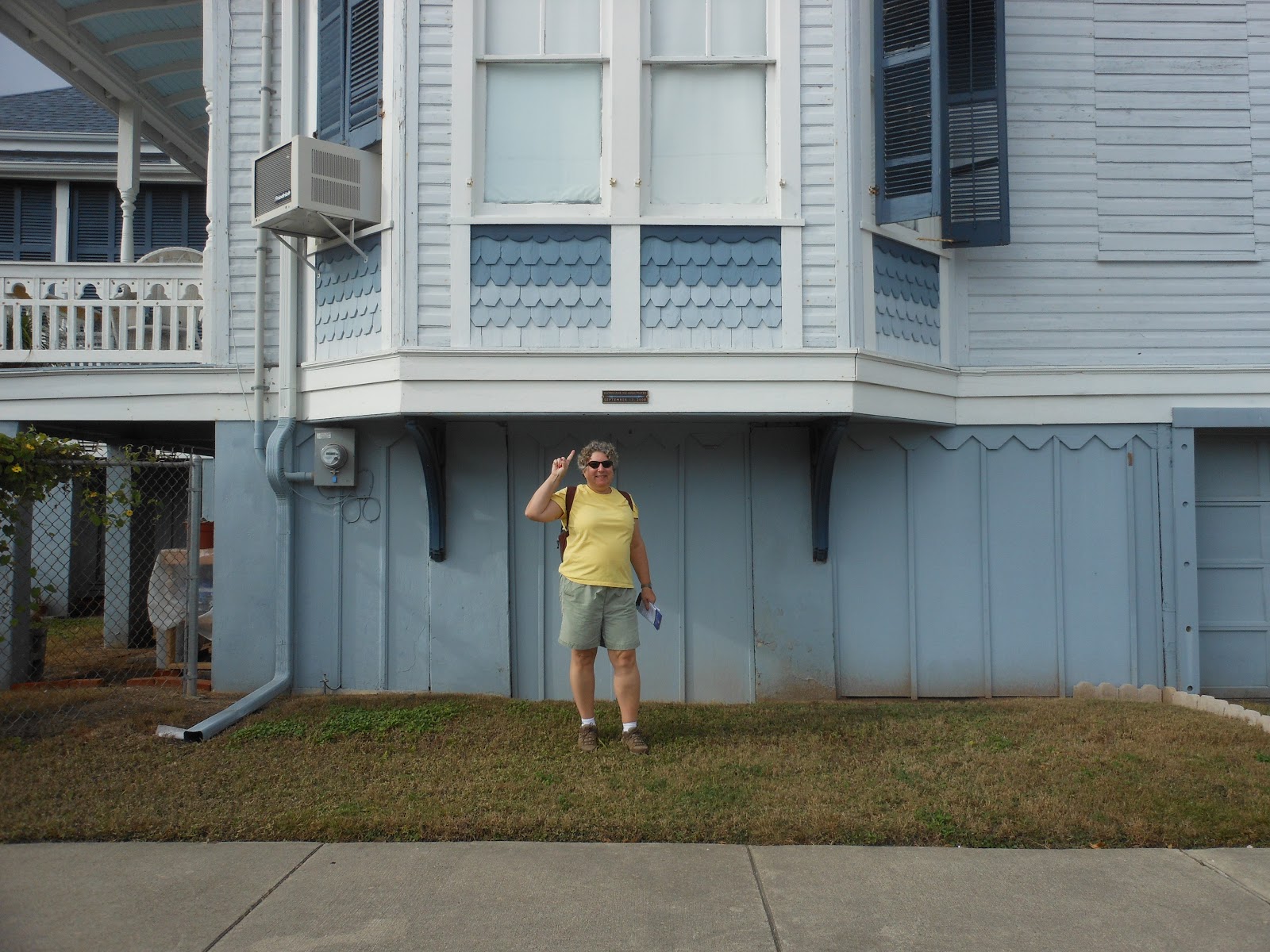
We passed many charming Victorian houses, particularly in the Queen Anne style.  Most of these homes had historical plaques.  Some also had plaques showing the uncomfortably high high-water mark from Hurricane Ike. It is obvious that a great deal of love and pride has gone into the restoration and maintenance of these homes.

Close-up of plaque in photo above


The Trube Castle: "the strangest house in a city of strange houses"

"Old Red"
Upon reaching the campus of the University of Texas Medical Branch, we were treated to "Old Red," another one of those red stone Romanesque Revival buildings that seem to be so popular in Texas.


Sacred Heart
We continued past many more lovely houses to Broadway, where we stopped in our tracks by Sacred Heart Catholic Church.  This stunning white building has Moorish, Byzantine, Gothic and Romanesque elements.  I've never seen anything like it.


View from the back of Sacred Heart


Bishop's Palace
Across the street from the church is Bishop's Palace.  Now a museum, this French Gothic stone "chateau" is another Galveston treasure.


At this point we turned and headed across to the other side of the island and the Seawall.


To be continued . . .